
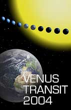

The Venus Transit 2004
... Brief InfoSheet D5
Space probes map Venus
The dense cloudy shell of the Venusian atmosphere was for centuries an unsurmoutable barrier to exploring the planet's surface. The first maps of the planet, drawn with the aid of Earth-based telescopes in the 17th century, showed only some vague features. One of the earliest maps was made by the amateur astronomer F. Fonatana in 1645. He thought that he had discovered oceans and continents - but this turned out to be an optical illusion.
The most famous planetary observers of the 18th century were Herschel and Schröter. As a young man, William Herschel moved from his native city of Hannover to England where he constructed the best telescopes of the time and discovered the planet Uranus. Johann Hieronymus Schröter was an amateur astronomer who built an observatory at Lilienthal near Bremen; he noticed some fuzzy dark spots on the bright disk of Venus and believed that he had discovered some high mountain ranges. Herschel disagreed with Schröter's observations of Venusian mountains but he also saw some dark features. Both observers agreed that the visible surface was nothing but a shell of clouds.
When photography was introduced to astronomy and led to a large number of new discoveries in the late 19th century, scientists were very hopeful that the mysterious cloud-covered surface of Venus might be revealed. But this hope did not materialise; photography was of no help. The first good images were produced by F. E. Ross in 1923 at Mount Wilson Observatory. Some mysterious features showed up in ultraviolet light but they were explained as cloudy shapes, not surface features.
In 1962, NASA launched the first successful Venus mission. Mariner 2 encountered Venus on 14 December 1962 at a distance of about 35,000 kilometres above the planet's surface. It found no appreciable magnetic field or radiation belts. A pair of heat-sensing radiometers that scanned the disk of Venus as the probe swept by produced data showing the surface to be dry and scorching hot, a fairly even 425 degrees Celsius over the entire planet.
In 1973, Mariner 10 returned the first pictures of Venus . They were taken in ultraviolet light and also provided a movie of the flow and turbulence in the upper atmosphere of Venus.
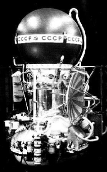
| | The Soviet Union continued its exploration of Venus in 1975 with two heavy spacecraft Venera 9 and 10 . They each had an orbiter and a landing unit. Two days before encounter, each detached a lander probe, allowing it to continue on to a shallow entry path into Venus' atmosphere. The landing sites were separated by a distance of 2000 kilometres. Both landing capsules sent back pictures of the surface of Venus which - despite the permanent dense clouds - turned out to be so bright that no artifical lighting was needed. The rocks had shadows. Each panorama showed a landscape with well distinguishable features up to 100 metres away. The landing sites were like stony deserts lacking both sand and dust, and covered by rocks measuring up to 10 metres across. In 1978, the US Pioneer-Venus 2 released four cone-shaped probes into the atmosphere. The orbiter's radar mapped out surface features from above, revealing a giant 3,200 x 1,600 km plateau, 5 km higher than the surrounding area. Elsewhere a huge canyon 1,400 km long, 280 km at the widest part, and 4.6 km deep was found, as well as several old impact craters 600 to 700 km across but only 0.5 km deep. |
In 1989, the USA launched the Magellan probe to Venus. Using synthetic aperture radar it made the best and most complete maps we have so far, covering (about 98% of the planet's surface) in 1990-1994. The resolution of the maps is as high as 100 metres and the elevation was measured with a resolution of 30 metres. Radar mapping revealed canyons, mountains, craters, volcanoes and volcanic formations.
The surface of Venus, according to the decision of the International Astronomical Union, has a feminine nomenclature: goddesses, heroines and other famous women.
Want to know more?
This topic is discussed in a more detailed way in the associated Extended InfoSheet.
Back to the List of Brief InfoSheets.