This topic did not meet a satisfying answer until now. The results of Table 4 by [CRS4 97] show large errors and poor correlation of 10-meter wind forecasts and analyses with data measured at Paranal or La Silla.
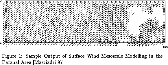
As for 2-meter temperature, much of ECMWF forecast error is due to the lack of observational data in the Antofagasta area could not be corrected by implementing a LAM (20 km mesh) without injection of new observational data. However unlike 2-meter temperature not only the forecasts, but also the analyses are poorly correlated. Obviously a global model such as ECMWF and even the LAM have a mesh much too large for the steep terrain surrounding astronomical sites. One has probably to go down to a mesoscale model such as the one described in Section 4.2 (ca. 500 m mesh). A sample output on Fig. 4 shows that local overspeed and shears are then clearly visible. Other more straightforward methods such a modified mass consistency models could be investigated to improve the case of 10-meter wind forecast.
| site | N | rKal | rper | rfor | rana | ||
| La Silla | 1242 | 2.5 | 0.64 | 2.9 | 0.59 | 0.57 | 0.43 |
| Paranal | 608 | 3.0 | 0.59 | 3.4 | 0.56 | 0.50 | 0.64 |
[10-meter wind speed Kalman Filter Postprocessing]
Absolute mean errors (![]() ) and correlations (r)
between observed 10-meter wind speed (m/s) and estimations by Kalman filter
post-processing ()Kal compared to persistence ()per, ECMWF
24-hour forecast ()for,
and ECMWF analysis ()ana. N is number of data used for comparison
during the period from 1989 to 1993.
) and correlations (r)
between observed 10-meter wind speed (m/s) and estimations by Kalman filter
post-processing ()Kal compared to persistence ()per, ECMWF
24-hour forecast ()for,
and ECMWF analysis ()ana. N is number of data used for comparison
during the period from 1989 to 1993.