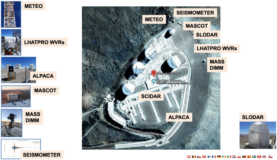
next up previous
Next: Forecasting Temperature and Wind Up: Forecasting Cloudiness and Water Previous: Meteorology and Satellite images

Forecast Skill

It was demonstrated that operational forecast of cloudiness and water vapour is feasible for observatories in Chile. The product illustrated on Fig. 3 consists of a daily estimate of the percentage of the sky to be clear, covered with transparent cirruses, or by opaque clouds, and the total amount of precipitable water vapour, for the next 24 hours by periods of 3 hours. In addition an up to 7-day daily outlook of status and tendency will be issued on qualitative grounds such as dry/moist and persisting/drying/moistening.

The image area trajectory is forecast with an rms error below 8% in image transparency units. The water vapour forecasts agree with infrared radiometric measurements taken from the ground at Paranal (NOAO Water Vapour Monitor) within an rms of 1.0 mm H2O (comparable to the dispersion between the WVM ground measurements and the Antofagasta radiosonde). Cloudy sky is successfully forecast 95% of the time at Paranal and 84% at La Silla, with respectively 2% and 7% false alarm rate.


Figure 2: Schematic diagram showing the main synoptic scale circulation systems that control water vapour and cirrus cloud cover advection patterns over the Southeastern Pacific Ocean. The satellite image is taken at 11 $\mu$m in the atmospheric IR window. Warmer surfaces appear dark and cold surfaces light. Clouds behave essentially as blackbodies at this wavelength, hence low clouds (being warmer) are medium grey and higher cloud (being cold) appear light grey or even white for the highest (about 15 km), coldest cirrus clouds.
\begin{figure}
\centerline{
\psfig {figure=fig2.ps,height=7cm,width=14cm}
}\end{figure}


Figure 3: Sample 6.7 $\mu$m Satellite Image and Output of Cloudiness and Water Vapour Forecast over La Silla Observatory: the model identifies at 15h UT, on Nov. 29, 1993, the image pixel which will most probably pass over the observatory 20 hours later
\begin{figure}
\centerline{
\psfig {figure=fig3.ps,height=7cm,width=14cm}
}\end{figure}


next up previous
Next: Forecasting Temperature and Wind Up: Forecasting Cloudiness and Water Previous: Meteorology and Satellite images
Marc Sarazin
10/7/1997