|
|
|
|---|---|
VLTI Station Position Technical Data |
|
The physical location of the array centre is defined as follows:
   Longitude: -70.40479659 degrees
    Latitude: -24.62794830 degrees
Each station is allocated an letter-digit identifier for easier
specification, e.g. "A1".
The following data is the station identifier, plus the coordinates of that
station in the reference frame of the rotated platform, followed by the
coordinates of the station as per an East-North grid, all specified in
metres.
Note that due to restrictions of the delay lines and optical feed paths,
not every arbitrary pair of stations may be chosen.
Station Position Coordinates
Following is a list of the station platform coordinates. The
platform coordinates (p,q) are rotated from the geographic
grid coordinates (e,n). This platform rotation, nu,
defined as a clockwise rotation from geometric north (i.e. east =
+90 degrees), is:
nu = -18.984 degrees
The geographic coordinates may be derived by rotating the
(p,q) coordinates:
   e  =  p * cos(nu)  +  q * sin(nu)
   n  =  q * cos(nu)  -  p * sin(nu)
where positive e is defined as the distance to the geometric east
of the array centre and positive n is defined as the distance to
the geometric north of the array centre.
_ID_______P__________Q__________E__________N____
 A0    -32.001    -48.013    -14.642    -55.812
 A1    -32.001    -64.021     -9.434    -70.949
 B0    -23.991    -48.019     -7.065    -53.212
 B1    -23.991    -64.011     -1.863    -68.334
 B2    -23.991    -72.011      0.739    -75.899
 B3    -23.991    -80.029      3.348    -83.481
 B4    -23.991    -88.013      5.945    -91.030
 B5    -23.991    -96.012      8.547    -98.594
 C0    -16.002    -48.013      0.487    -50.607
 C1    -16.002    -64.011      5.691    -65.735
 C2    -16.002    -72.019      8.296    -73.307
 C3    -16.002    -80.010     10.896    -80.864
 D0      0.010    -48.012     15.628    -45.397
 D1      0.010    -80.015     26.039    -75.660
 D2      0.010    -96.012     31.243    -90.787
 E0     16.011    -48.016     30.760    -40.196
 G0     32.017    -48.0172    45.896    -34.990
 G1     32.020   -112.010     66.716    -95.501
 G2     31.995    -24.003     38.063    -12.289
 H0     64.015    -48.007     76.150    -24.572
 I1     72.001    -87.997     96.711    -59.789
 J1     88.016    -71.992    106.648    -39.444
 J2     88.016    -96.005    114.460    -62.151
 J3     88.016      7.996     80.628     36.193
 J4     88.016     23.993     75.424     51.320
 J5     88.016     47.987     67.618     74.009
 J6     88.016     71.990     59.810     96.706
 K0     96.002    -48.006    106.397    -14.165
 L0    104.021    -47.998    113.977    -11.549
 M0    112.013    -48.000    121.535     -8.951

 U1    -16.000    -16.000     -9.925    -20.335
 U2     24.000     24.000     14.887     30.502
 U3     64.0013    47.9725    44.915     66.183
 U4    112.000      8.000    103.306     43.999
The stations U1, U2, U3 and U4 are
occupied by the unit telescopes.
Station Map
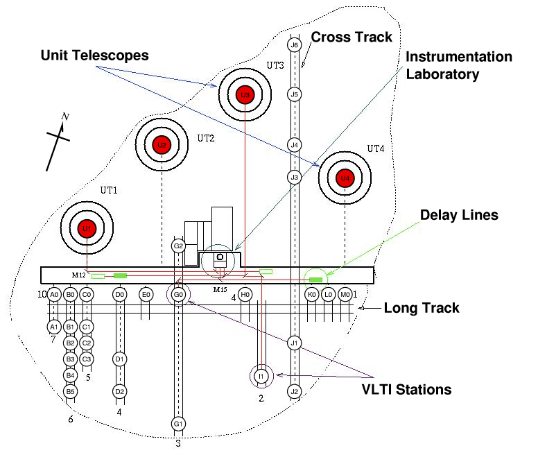
|
Click on the image icon to see the large-scale version (72kbytes) of the map displaying the station positions at the Paranal Observatory site. |
| Send comments and questions via https://support.eso.org/ |