|
|
|
|---|---|
VLTI Gravity |
|
The GRAVITY Exposure Time Calculator is a software tool to prepare observations. The objective of this software tool is to estimate the feasibility of an observation and the necessary telescope time at Phase 1 (before the proposal is submitted), as well as determine the suitable instrument parameters at Phase 2 (to be input to P2PP for the preparation of the OBs). Thanks to the fringe tracking capability of the instrument, it will be possible to integrate the spectrally dispersed signal from the Science Combiner. Therefore, the GRAVITY ETC will provide:
GRAVITY has two principal observing modes:
Two spectral resolution settings are available for the Science combiner:
Two polarization settings will be available for each of the spectral resolutions of the Science target:
The following options are available to describe the spectrum of the science target.
The target model can be defined by a template spectrum which is scaled to the provided magnitude and filter. References: Pickles (1998, PASP 110, 863); Coleman et al.: 1980ApJS; Kinney at al.: 1996ApJ.
The target model is a blackbody defined by its temperature, expressed in Kelvin. The intensity distribution is scaled to the object magnitude.
Users can upload a file with the spectral flux distibution to the ETC server.
Supported formats:
Supported formats:
In both cases the values in the first column should be the wavelength in nm units and ascending order; the second column is the the flux density in a unit proportional to erg/cm2/s/A.
The absolute flux scale is not significant since the spectrum will be scaled to the given magnitude in the given band. The maximum file size is 2 MB.
NOTE! The wavelength range of the uploaded spectrum must cover the spectral range of the selected instrument mode as well as the wavelength range of the photometric band in which the magnitude is given.
The input spectrum is a single emission line. It is an analytical Gaussian, centered on the Wavelength parameter, defined by its total Flux and full-width at half-maximum FWHM. Line flux is given in 10-16 erg.cm-2.s-1.
NB: When requesting a single line as input spectrum, the magnitude parameter is not taken into account. Only the line flux will be used to determine the signal magnitude. The FWHM of a single line is limited by the sampling. If the requested FWHM is too narrow, it will be replaced by the minimum supported value, and a warning will be issued in the beginning of the result page.
Together with the declination of the target on sky and the chosen baseline quadruplet, the ETC evaluates the fringe visibility and photometric flux measured at the detector. It also checks that the fringe tracking is possible in this configuration. The Science Target may be used to calibrate the zero point of the metrology by switching the two fields of GRAVITY. Considering the small maximum separation of the GRAVITY dual field observations, the angular distance between the two objects is considered negligible for the computation of the projected baselines, hence the user will specify only a single set of coordinates.
The available target geometries for the users are:
The target is represented by a single disc with uniform intensity.
The target intensity is represented by a gaussian model.
The target intensity is represented by a elliptical gaussian model.
The target is represented by a couple of uniform discs with the specified sizes, separation and relative fluxes.
The target name is resolved by Simbad. This service determines the coordinates of the target automatically.
The user defines the science target hour angle during the observation (beginning, end, and step).
The following options are available to describe the spectrum of the fringe tracker:
The target model can be defined by a template spectrum which is scaled to the provided magnitude and filter. References: Pickles (1998, PASP 110, 863); Coleman et al.: 1980ApJS; Kinney at al.: 1996ApJ.
The target model is a blackbody defined by its temperature, expressed in Kelvin. The intensity distribution is scaled to the object magnitude.
User-defined spectrum.
In addition to the spectral energy distribution of the Fringe Tracking (FT) target, another useful parameter for the estimation of the feasibility of the fringe tracking is its geometry. The fringe tracking object is represented by a uniform disc. The user can specify the diameter of the disc and the separation from the science target.
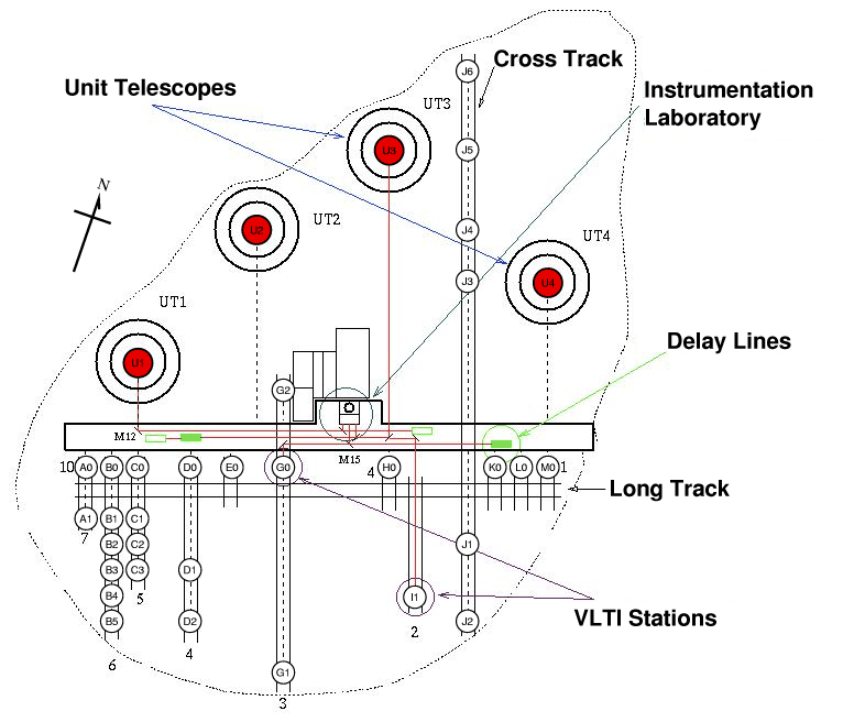
GRAVITY will be usable either with four Unit Telescopes or with four Auxiliary Telescopes. For reasons of optical efficiency, it will not be possible to use a combination of both UTs and ATs sim- ultaneously (e.g. 2 UTs + 2 ATs). As a consequence, the user will be given only the choice of four UTs with fixed (x,y,z) positions or four ATs. For an AT configuration, the user will select the quadruplet of stations in a list of the available VLTI configurations for the considered observing period. See below the available stations.
| Light Collector | Possible Stations |
|---|---|
| Unit Telescopes | U1, U2, U3, U4 |
| Auxiliary Telescopes | A0, A1, B0, B1, B2, B3, B4, B5 C0, C1, C2, C3, D0, D1, D2, E0, G0, G1, G2, H0, I1, J1, J2, J3, J4, J5, J6, K0, L0, M0 |
The list of offered AT configurations is available at: VLTI Configurations
With the advent of instruments using new adaptive optics (AO) modes, new turbulence parameters need to be taken into account in order to properly schedule observations and ensure that their science goals are achieved. These parameters include the coherence time and the fraction of turbulence taking place in the atmospheric ground layer, in addition to the seeing. Starting from Period 105, the turbulence constraints are standardised to the turbulence conditions required by all instruments and modes, whether they are seeing-limited or AO-assisted.
The handling of atmospheric constraints thus changes for both Phase 1 (proposal preparation) and Phase 2 (OB preparation). In Phase 1, the seven current seeing categories are replaced by seven turbulence categories for all instruments. Each category can be defined by other parameters than a pure seeing threshold, depending on the instrument. For all instruments, all categories share the same statistical probability of realisation, which is key for an accurate time allocation process. In Phase 2, the image quality will still be the only applicable constraint for seeing-limited modes, whereas the same turbulence category as for Phase 1 will be used for diffraction-limited modes.
Users are encouraged to read the general description of these changes for Phase 1 and Phase 2 on the Observing Conditions webpage, as well as instrument User Manuals for specifics per instrument.
|
The definitions of seeing and image quality used in the ETC follow the ones given in Martinez, Kolb, Sarazin, Tokovinin
(2010, The Messenger 141, 5)
originally provided by Tokovinin (2002, PASP 114, 1156) but corrected by Kolb (ESO Technical Report #12):
Seeing is an inherent property of the atmospheric turbulence, which is independent of the telescope that is observing through the atmosphere; Image Quality (IQ), defined as the full width at half maximum (FWHM) of long-exposure stellar images, is a property of the images obtained in the focal plane of an instrument mounted on a telescope observing through the atmosphere. The IQ defines the S/N reference area for non-AO point sources in the ETC. With the seeing consistently defined as the atmospheric PSF FWHM outside the telescope at zenith at
500 nm, the ETC models the IQ PSF as a gaussian, considering the gauss-approximated transfer functions of the atmosphere, telescope and
instrument, with s=seeing, λ=wavelength, x=airmass and D=telescope diameter:
For fibre-fed instruments, the instrument transfer function is not applied. The diffraction limited PSF FWHM for the telescope with diameter D at observing wavelength λ is modeled as:
\(F_{\text{Kolb}} \) is the Kolb factor (ESO Technical Report #12):
|
The sky background model is based on the Cerro Paranal Advanced Sky Model, also for instruments at la Silla, except for the different altitude above sea level. The observatory coordinates are automatically assigned for a given instrument.
By default, the airmass and moon phase parameters are entered manually. The sky model will use fixed typical values for all remaining relevant parameters (which can be seen in the output page by enabling the check box "show skymodel details").
Alternatively, a dynamic almanac widget can be enabled to facilitate assignment of accurate sky model parameters for a given target position and time of observation. The sky radiation model includes the following components: scattered moonlight, scattered starlight, zodiacal light, thermal emission by telescope and instrument, molecular emission of the lower atmosphere, emission lines of the upper atmosphere and airglow continuum.
The almanac is updated dynamically by a service on the ETC web server, without the need to manually update the web application.
Notes about the algorithms, resources and references for the almanac are available here. A more advanced version of the almanac is included in our SkyCalc web application, which provides more input and output options.
Hovering the mouse over an input element in the almanac normally displays a pop-up "tooltip" with a short description.
The upper left part of the almanac box refers to the date and time of observation.
This can be done with a UT time or a MJD. A date/time picker widget will appear when
the UT input field is clicked, but the UT can also be assigned manually. In any case, the
UT and MJD fields are dynamically coupled to be mutually consistent.
The two +/- buttons can be used to step forward or backward in time by the indicated step and unit per click. The buttons can be held down to step continuously until released.
The third of night corresponding to the currently selected time is indicated. This is an input parameter to the airglow component in the sky model. Twilight levels (civil, nautical and astronomical) referring to the sun altitude ranges are also indicated in the dynamic text. These levels refer to the sun altitude:
The target equatorial coordinates RA and dec can be assigned manually in the two input
fields or automatically using the SIMBAD resolver to retrieve the coordinates.
If the lookup is successful, an "info" link will open a window in which the raw SIMBAD response can be inspected.
The units can be toggled between decimal degrees and hh:mm:ss [00:00:00 - 23:59:59.999] for RA and dd:mm:ss (or dd mm ss) for dec. A whitespace can be used as separator instead of a colon.
The table dynamically displays the output from the server back-end service, including temporal and spatial coordinates for the target, Moon and Sun. The bold-faced numbers indicate the parameters normally relevant in the phase 1 proposal for optical instruments. The numbers appear in red color if they are out of the range supported by the sky model.
The chart dynamically shows the altitude and equivalent airmass as function of time for the moon and target,
centered on midnight for the currently selected date.
The green line, which refers to the currently selected time,
can be dragged left and right to change the time, dynamically coupled with the sections in the Time section.
A more advanced version of the almanac is included in our SkyCalc web application, which provides more input and output options.
The available parameters for the users are:
The minimum possible exposure time (min DIT) depends on the chosen spectral resolution. The higher the spectral resolution, the larger the number of pixels to be read out from the detector, and therefore the higher the min DIT. There is one min DIT value per spectral resolution setting. The selection of polarization splitting option does not result in an increase in min DIT, as the read out window on the detector does not change compared to the non-split setting. The min DIT values for the three different spectral resolution settings of the SC are listed below.
| Spectral Resolution | Number of Pixels | Minimum DIT (ms) |
|---|---|---|
| 22 | 640x10 | 1.5 |
| 500 | 640x256 | 30 |
| 4000 | 640x2048 | 300 |
| Send comments and questions via https://support.eso.org/ |