The Long Term Follow-up of the Astroclimate at Paranal
| HOME | INDEX | SEARCH | HELP | NEWS |
The Long Term Follow-up of the Astroclimate at Paranal | |||||
|
| The Astronomical Site Monitor (meteo mast, dimm tower and control room) is visible at the extreme left of this NW-SW profile of the Paranal Observatory. | 
|
| The long term follow-up of observing conditions at an astronomical site is a tool for understanding the effects of climatic cycles (see for example: An analysis of the relationship of El-Nino to the cloud cover at ESO observatories The ESO Messenger 90, December 97 (ps file)) complemented in March 2000 by Chile Astroclimate, a Biannual Update The ESO Messenger 99, on the quality of astronomical observations. A seminar given to the ESO staff on a 20-years summary of Paranal/LaSilla astroclimate (pdf, Oct. 2004). |
| The monthly mean seeing at Paranal measured at 6 meter above ground and corrected for zenith and a wavelength of 0.5 micron. | 
|
| The current VLT-ASM DIMM started operation on month 137. During the months 126-135, the portable monitor in use could only work in low wind conditions, the data have been increased by 15% to account for that effect. |
|
During the end of 1998,
the unusual conditions of bad seeing which prevailed during
UT1 science verification
still occurred at Paranal with a frequency higher than in the past. We have identified
that this new feature was strongly correlated with a given wind pattern. Microthermal measurements
on a 30m high mast have shown (A&A SS 144, 39-44, May 2000) that this additional turbulence
was not limited to the first few tens of meter above ground which accounted for less than 10%
of the total seeing. Moreover, due to finite outer scale effects,
the 8m VLT Unit Telescopes suffer a (10% in V, more in the IR) smaller
degradation than what the ASM-DIMM is predicting. However the new wind pattern (NNE to ENE) occurs at the expense of the standard Paranal WNW to NNW wind. As a consequence the very good seeing (smaller than 0.5 arcsec) is less frequent than normal (only 3% of the time in the period OCT-DEC 98 against 30% at the same period in 1997). |
| The good seeing wind rose: for each wind direction, the percentage of the time when a given direction was coincident with seeing better than 0.5 arcsec | 
|
| The bad seeing wind rose: for each wind direction, the percentage of the time when a given direction was coincident with seeing worse than 1.5 arcsec | 
|
| The fraction of nighttime when the wind blows from the good seeing direction since the end of levelling of Paranal | 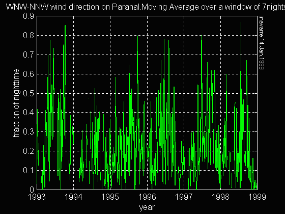
|
| The fraction of nighttime when the wind blows from the good seeing direction since the beginning of the Paranal site survey | 
|
| The fraction of nighttime when the wind blows from the bad seeing direction since the end of levelling of Paranal | 
|
| The fraction of nighttime when the wind blows from the bad seeing direction since the beginning of the Paranal site survey | 
|
| Histogram of the temperature difference between 30m and 2m height during bad seeing conditions | 
|
| The bad seeing is located in the lowest layers down to the surface: it is well correlated with a large vertical gradient of the air temperature in the first 30m above ground |
| Histogram of the temperature difference between 30m and 2m height during good seeing conditions | 
|
| The good seeing is characterized by an abscence of turbulence in the surface layer. The vertical gradient of the air temperature in the first 30m above ground is close to zero. |
| The wind flow (RISOE study, 1990) at 10m above ground in the Paranal area for an upwind undisturbed direction of 330 degree corresponding to the good seeing situation. | 
|
| In the standard good seeing situation, the flow above Paranal comes from the very steep coastal slopes. The turbulent flow from the large valley North of Paranal is forced to two passes between Montura (M1,M2), NTT (N) and Paranal peaks (the later is visible on the photo below). |
 (Photo obtained on
December 12, 1998-IPS).
(Photo obtained on
December 12, 1998-IPS).